modified Lambert conformal map projection
- modified Lambert conformal map projection
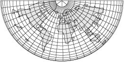
A modification of the Lambert conformal projection for use in polar regions. One of the standard parallels is at latitude 89°59’58” and the other latitude is at 71° or 74°. The parallels are expanded slightly to form complete concentric circles. Also called Ney’s map projection.
Aviation dictionary.
2014.
Look at other dictionaries:
MAP — See modified American plan. * * * I Graphic representation, drawn to scale and usually on a flat surface, of features usually geographic, geologic, or geopolitical of an area of the Earth or of any celestial body. Globes are maps represented on… … Universalium
projection — In cartography, any systematic arrangement of parallels and meridians portraying a quasi spherical planetary surface on a plane of a map. See Mercator map projection, Lambert conformal conic map projection, and international modified poly conic… … Aviation dictionary
Scale (map) — The scale of a map is defined as the ratio of a distance on the map to the corresponding distance on the ground. If the region of the map is small enough for the curvature of the Earth to be neglected, then the scale may be taken as a constant… … Wikipedia